- Research
- Open access
- Published:
Exploring the patterns of alpine vegetation of Eastern Bhutan: a case study from the Merak Himalaya
SpringerPlus volume 4, Article number: 304 (2015)
Abstract
A survey was conducted from March to September 2012 along the altitudinal gradient of the Jomokungkhar trail in the Merak Himalaya of Sakteng Wildlife Sanctuary to study the floristic compositions and the patterns of alpine vegetation of Eastern Bhutan. The vegetation of the sampled plots is classified into five types of communities based on the hierarchical cluster analysis at similarity index 63% viz., (1) Riverine Community; (2) Abies–Rhododendron Woodland Community; (3) Juniperus Scrub Community; (4) Rhododendron Krummholz and (5) Alpine Meadow, based on the floristic compositions. In addition, it was noticed that the fragile alpine environment of the Merak Himalaya has high plant diversity and important plants that are susceptible to the anthropogenic pressures.
Background
The Bhutan Himalaya is the main part of the Eastern Himalaya, which spans ca. 700 km (Oshawa 1987), located at the junction of two major biogeographic realms of the Indo-Malayan and the Palearctic. The region composed of mountains of simple slopes separated by deep river gorges and valleys consists of a number of unique habitats ranging from subtropical jungles in the south to alpine zones in the north. Although, the forests of Bhutan are still well managed under the strict rule of conservation policies, its success is likely to become a questionable issue owing to ever increasing pressures on natural environment from the increasing population and associated anthropogenic disturbances. Despite the remarkable efforts made and literatures available, very least is known about its flora and conservation strategies. The botanical studies of the recent past in the Bhutan Himalaya have focused mostly on the endemic, rare, and threatened plants or a particular taxon rather than the general biodiversity as mostly found in the Flora of Bhutan and some other works (Campbell and Long 1987; Clement 1999, 2001; Long and Rae 1991; Grierson and Long 1983, 1984, 1987, 1991, 1999, 2001; Grierson and Springate 2001; Gurung 2006; Gyeltshen 2012; Hoch 1991; Mill 1999, 2001; Pearce and Cribb 2002; Rae 1991; Wilson 1991). Therefore, floristic records of Bhutan may be incomplete and shall require further surveys and studies, especially in the remote and understudied areas. At present, Bhutan has 51.32% of its land covered with forests that are preserved through protected area systems and biological corridors (Nature Conservation Division 2001; World Wildlife Fund Bhutan and Sakteng Wildlife Sanctuary 2011).
Sakteng Wildlife Sanctuary (referred to as SWS hereon) was declared as a protected area of Bhutan in 2003. It is located in Trashigang district in the east of Bhutan and shares border with the adjacent Himalayan Range of Arunachal Pradesh in India. It is one of the protected areas in Bhutan with very rich biodiversity and amazingly houses ca. 35 species of Rhododendron L. (Wangchuk 2010) out of 46 recorded, so far, in the country (Pradhan 1999). Many other endemic, rare, and threatened plants also occur in SWS. In spite of the facts known, the previous account of botanical study in SWS is rather limited. Thus, the forests of these areas are under huge pressure from the local inhabitants and animal grazing. One ecologically important area of SWS is Merak: one of the remotest and most difficult areas to access for vegetation surveys and related research. The mountainous Merak has been also known to have the rich diversity of species of Rhododendron L. and many other endemic, rare, and threatened plants (Wangchuk 2010). In general, the vegetation of Merak is apparently composed of three types of forests: cool-temperate forest, subarctic forest, and dry alpine scrubs (Oshawa 1987; Grierson and Long 1983), with the major forest type composed of Abies densa Griff. This area is one among the scientifically unexplored areas, which is pressurized by anthropogenic disturbances. This work tried to evaluate the vegetation structure, composition and the distribution patterns along the altitudinal gradient ranging from the riverine forest of 3,320 m to the alpine meadow zone of 4,510 m of the Merak Himalaya, Trashigang district in East Bhutan.
Methods
The study area
Merak is located in Trashigang, the easternmost district of Bhutan. It lies within the preserved area of SWS (Figure 1a, b). The field survey was conducted along the altitudinal gradient of the Jomokungkhar trail (N27°17.762′–E091°50.268′ to N27°15.382′–E091°48.758′) of Merak. The trail is ca. 10.5 km in length, ranging from 3,320 m asl. (Ngera Ama river bank, Plot1; Table 1) to as high as 4,510 m asl. (Jomokungkhar top, Plot 12; Table 1). Within this range, various plant habitats, viz., woodland, scrubs, field layer, open ground, edges and aquatic terrestrial transitions are seen. The major type of forest is composed of coniferous woodland mixed with Rhododendron broadleaves and a few species of Junipers. However, it gradually changes to Rhododendron krummholz and to alpine meadow at the summit.

a Map of Bhutan showing SWS. b Map of SWS showing Merak and Jomokungkhar Trail. c Jomokungkhar trail and study plots.
Topography, geology and climate
The topography of Merak Himalaya is mountainous with East–West oriented upland valleys with varying degrees of slopes. The Merak Himalaya has an aggregate of mostly podzol and alpine meadow soils, found above 4,200 m asl (Okazaki 1987). With regard to the climate, Bhutan is the most unknown region in the monsoon Asia (Eguchi 1987). It has a wide variety of climatic conditions influenced by topography, elevation, and rainfall. It is divided into six climatic zones, viz. wet subtropical, humid subtropical, dry subtropical, warm temperate, cool temperate and alpine. Accordingly, the Merak Himalaya falls within alpine climatic zone with a mean temperature of 5.5°C and annual average rainfall of ≤650 mm (Department of Agriculture 1988). However, the paucity of information on monthly rainfall and temperature of the Merak Himalaya is due to the lack of meteorological stations within and in the adjacent areas.
The study plots
Twelve study plots (Figure 1c; Table 1) were subjectively selected along the proposed transect line. Transect line was chosen in the least disturbed vegetation, which was assessed based on presence of alien species and anthropogenic disturbances. The homogenous continual natural condition and/or the presence and absence of natural remnant patches or characteristically unique floristic composition from the surrounding vegetation types were also included as plots selection criteria. In addition, various aspects of vegetation such as the presence of relict, pattern, and visual observation of species abundance were incorporated for choosing the plots. Table 1 depicts the characteristic properties of each study plot. The abundance of plant species was measured by cover-abundance estimation using the Domin-Krajina scale (Kent and Coker 1994). The numerical scores were recorded as follows (also see Table 2): + = a single individual, no measurable cover; 1 = 1–2 individuals with normal vigor, no measurable cover; 2 = several individual, but less than 1% cover; 3 = 1–4% cover; 4 = 4–10% cover; 5 = 11–25% cover; 6 = 26–33% cover; 7 = 34–50% cover; 8 = 51–75% cover; 9 = 76–90% cover; 10 = 91–100% cover.
Plant specimens from the study sites were collected once in a month, which commenced from March to September 2012, assuring full coverage of the flowering season for all plants. Some plant species occurring outside or in the adjacent areas of the study plots were also collected to obtain a complete checklist and precise pattern of diversity. The voucher specimens are deposited in the National Herbarium of Bhutan, Serbithang, Thimphu Bhutan, and the local herbarium of SWS, Department of Forest and Park Services (DoFPS), Ministry of Agriculture, Bhutan.
The Cluster Analysis was performed using PC-ORD software version 5.19 to classify the vegetation of the Merak Himalaya into different communities based on species abundances and habitats (Figure 2). The community types obtained from the analysis are described, photographed, and presented in profiles.

Cluster analysis dendrogram based on species abundances and habitats.
The floristic richness of the study areas was determined by the direct count of the number of species, genera, and families recorded. The graphical and tabular distribution pattern of a group of each life form and the overall distribution pattern of vascular plants of the study areas are presented.
Results and discussions
The vegetation patterns of the Merak Himalaya
The list of the plant species recorded and their abundance in each selected plot are shown is Table 2. Based on species abundance, twelve study plots identified along the line transect were grouped into community types by cluster analysis using PC-ORD. The hierarchical cluster analysis at similarity index 63% showed five types of communities (Figure 2; Table 3). The analysis was performed based on the species abundances and their habitats.
-
1.
Riverine community (Plot 1)
Such type of community usually occurs alongside the river/streams (Figures 3, 4, 5a), where some of its portion experiences severe flooding during the heavy monsoon. It is composed of multiple microhabitats such as terrestrial scrubs, open ground, and aquatic-terrestrial transition. Most common terrestrial plants adorning such community are Senecio raphanifolius Wall. ex DC., Rhododendron campylocarpum Hook. f., Rumex nepalensis Spreng., Pedicularis siphonantha D. Don, and Geranium spp. Myricaria rosea W. W. Sm, Cardamine griffithii Hook. f. & Thomson and Epilobium gouldii P. H. Raven are some aquatic-terrestrial transition plants. Fragaria nubicola (Hook. f.) Lindl. ex Lacaita and Anaphalis spp. are among the herbaceous plants that occupy the open ground habitat.
-
2.
Abies–Rhododendron Community (Plot 2–6)
Figure 3 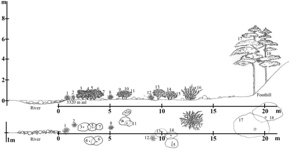
The vegetation profile the Riverine community of plot 1 (N27°17.762′; E091°50.268′) on the line transect of the Jomokungkhar trail: 1, 2, 8, 12—Myricaria rosea W.W.Sm; 3, 4, 5, 6, 7, 9, 10, 11, 13, 14, 15—Rhododendron campylocarpum Hook. f.; 16—Berberis virescens Hook. f.; 17, 18—Abies densa Griff.
Figure 4 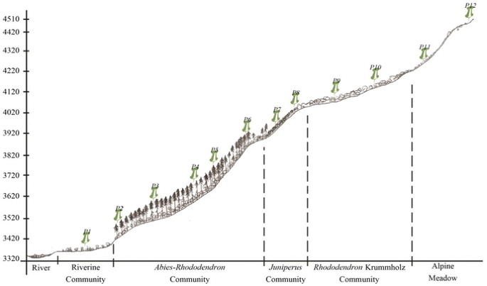
A schematic profile of vegetation pattern along the altitudinal gradient of the Merak Himalaya, Sakteng Wildlife sanctuary.
Figure 5 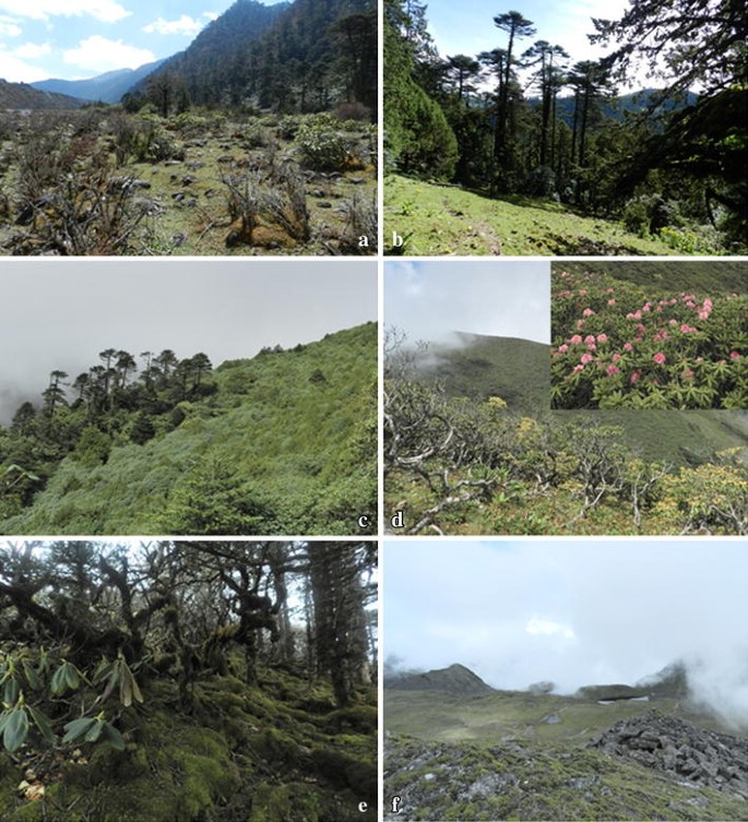
a Riverine community. b Abies–Rhododendron community. c Juniperus community. d Rhododendron krummholz. e Bryophyte covering ground floor of Rhododendron krummholz. f Alpine meadow.
This type of community is rather restricted to the woodland habitat with sparsely occurring epiphytic ferns and dense bryophytes. It is mainly composed of a single tree species A. densa Griff—with high canopy and Rhododendron spp. as moderate occupants forming its understory vegetation (Figures 4, 5b, 6). Such vegetation is usually hilly with slopes of ±45° (Table 3). A very few species of shrubs like Rosa sericea Lindl., Juniperus sp., Rhododendron sp., and Berberis spp.; and herbaceous plants like Fragaria daltoniana J. Gay, Primula spp., Gaultheria trichophylla Royle., and Arisaema elephas Buchet are seen on its ground floor.
Figure 6 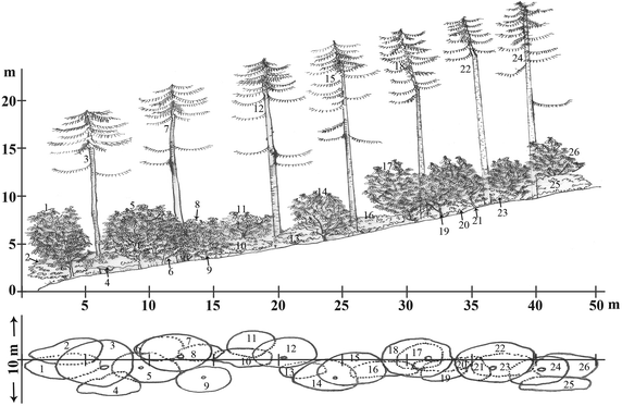
The vegetation profile of Abies–Rhododendron community of plot 3 on the line transect of the Jomokungkhar trail: 3, 7, 12, 15, 18, 22, 25—Abies densa Griff.; 2, 8, 19, 25—Rhododendron argipeplum Balf.f. & R.E. Cooper; 6, 11, 26, 23—Rhododendron lanatum Hook.f.; 9, 21, 26—Rhododendron hodgsonii Hook. f.; 4, 10, 13, 16—Rhododendron fulgens Hook. f.; 1, 5, 14, 17—Rhododendron kesangaie D.G. Long & Rushforth.
-
3.
Juniperus Scrub Community (Plot 7–8)
This is a small community forming above timberline vegetation (Figures 4, 5c). Mainly composed of Juniperus recurva Buch.-Ham. ex D. Don and J. squamata Buch.-Ham. ex D. Don, it is moderately to highly scattered vegetation (Table 3). Gentiana spp. and Rhododendron nivale Hook. f. are some other common species found in such community.
-
4.
Rhododendron Krummholz Community (Plot 9–10)
The Rhododendron krummholz is another type of community forming above timberline vegetation with a rich growth of bryophytes on its ground floor (Figure 5e). Krummholz here is referred to as the crooked and contorted forest formed by the effect of the wind current (Figure 5d). It is a fairly mixed vegetation of sparse and dense distribution of Rhododendron spp. Open grounds, gaps, and margins of such community usually have a high diversity of herbaceous vascular plants (Table 3). Potentilla saundersiana var. caespitosa (Lehm.) Th. Wolf, Primula spp., Bergenia purpurascens (Hook. f. & Thomson) Engl., Oxygraphis endlicheri (Walp.) Bennet & Sum. Chandra are some other taxa found in this type of community.
-
5.
Alpine meadow Community (Plot 11–12)
The Alpine Community (also see Figures 4, 5f) of the Merak Himalaya has a high diversity of herbaceous vascular plants (Table 3). This fragile natural mountain meadow is mostly adorned by the abundant growth of Potentilla coriandrifolia D. Don, Bistorta sp., Cyananthus macrocalyx subsp. spathulifolius (Nannf.) K. K. Shrestha, shrubby Rhododendron setosum D. Don, and numerous species of unidentified grasses.


The riverine community showed the richest diversity of herbaceous vascular plants (see Table 3) as compared to rest of the communities, despite the influence of anthropogenic disturbances. Some factors like soil quality, forest productivity, flat favorable topography, and overlapping of different plant assemblages forming an ecotone of evergreen coniferous forest and mixed broadleaved forest of the lower elevation region attribute for its rich floristic diversity.
The coniferous woodland, Abies–Rhododendron community, is the least species rich community (see Table 3). Adhikari (2005) reported that seedling establishment of the dominant species, A. densa Griff., of this community was thriving well under its own canopy with fairly distributed Rhododendron spp. in its understory. However, the phenomenon is not similar to other shrubs and herbaceous species. With the richness of epiphytic vascular plants dwindling with increasing altitude, edaphic factor and local topography of the community are other contributing factors.
The Abies–Rhododendron community of the Merak Himalaya has steep slopes of 45° or more (see Table 3). Such steep topography would then slow down the rate of seedling establishment and had made the soil poor through periodical leaching. Another apparent factor of rather low diversity in such community is the anthropogenic disturbance: animal grazing, tree felling, and deliberate burning of forest/individual species (also see Adhikari 2005). It is also expected that the high canopy (as high as up to 30 m) of A. densa Griff., and the broad-leaved Rhododendron spp. in its understory obstruct the light penetration to the ground, which is required by every plant for their successful growth and propagation.
On the other hand, the Rhododendron krummholz/scrubs of the Merak Himalaya provide special conditions for the diverse plant species to grow together in the same community through niche gapping. Therefore, this community also has a rich diversity of herbaceous plants along with rigorous growth of Rhododendron L. itself. Bistorta griffithii (Hook. f.) Grierson (Polygonaceae), Potentilla saundersiana var. caespitosa (Lehm.) Th. Wolf (Rosaceae), Bergenia purpurascens (Hook. f. & Thomson) Engl. (Saxifragaceae) flower in June. Within the same niche, other species of the same families drawing the same nutrients, e.g. Rheum acuminatum Hook. f. & Thomson, Potentilla fruticosa var. arbuscula (D. Don) Maxim., and Saxifraga hispidula D. Don flower in August. However, the pride of this community’s richness is counterbalanced by animal grazing. Palatable plants are grazed and unpalatable plants are trampled. In addition, it was noticed that there is higher species richness in the high alpine community than in the lower elevation communities. The alpine soil is characteristically poor in nutrients and significantly degraded easily by global climate change, grazing, human activities, and rodents (Wen et al. 2010). However, no mystical phenomenon was observed. The growth of herbaceous plants in the alpine community of the Merak Himalaya is well supported by less degree of anthropogenic disturbances and its topography. Slopes of this community are steep and over 45° where animals cannot access easily for grazing. There wasn’t any sign of impact to the environment by rodents. In the Himalayan Merak, human intervention in the succession of natural alpine environment is comparatively low as long as grazing practice is void.
A tremendous effort has been put by the management of Sakteng Wildlife Sanctuary to preserve the pristine natural environment of the region. Despite the strict regulations in place, grazing practices and trespassing of animal migrations can be seen around the “Jomophodrang” core zone. Such activities, if continued would pose threat to the fragile alpine ecosystem, where growth of many species is confined to a very small and restricted habitat. Total protection of the ecosystem would be difficult as long as the anthropogenic pressure persists.
Endnotes
aRenewable Natural Resources.
References
Adhikari BS (2005) Floristic characteristics and vegetation patterns in Sakteng Wildlife Sanctuary. WWF-Bhutan & Nature Conservation Division, Bhutan
Campbell EJF, Long DG (1987) Geraniaceae. In: Grierson AJC and Long, D.G (eds) Flora of Bhutan, vol 1(3). Royal Botanic Garden and Royal Government of Bhutan, pp 744–748
Clement RA (1999) Labiatae. In: Long DG (ed) Flora of Bhutan, vol 2(2). Royal Botanic Garden and Royal Government of Bhutan, pp 938–1002
Clement RA (2001) Campanulaceae. In: Springate LS (ed) Flora of Bhutan, vol 2(3). Royal Botanic Garden and Royal Government of Bhutan, pp 1375–1397
Department of Agriculture (1988) Data from meteriological section. Ministry of Agruculture and Forests, Thimphu
Eguchi T (1987) Synoptic analysis of temperature, precipitation and moisture conditions in the Bhutan Himalayas. In: Oshawa M (ed) Life zone ecology of the Bhutan Himalaya, vol 1. Chiba University, Japan, pp 209–248
Grierson AJC, Long DG (1983) Flora of Bhutan, vol 1(1). Edinburgh
Grierson AJC, Long DG (1984) Flora of Bhutan vol 1(2). Edinburgh
Grierson AJC, Long DG (1987) Flora of Bhutan, vol 1(3). Edinburgh
Grierson AJC, Long DG (1991) Flora of Bhutan, vol 2(1). Edinburgh
Grierson AJC, Long DG (1999) Flora of Bhutan, vol 2(2). Edinburgh
Grierson AJC, Long DG (2001) Flora of Bhutan, vol 2(3). Edinburgh
Grierson AJC, Springate LS (2001) Asteraceae. In: Springate LS (ed) Flora of Bhutan, vol 2(3). Edinburgh, pp 1397–1632
Gurung DB (2006) An illustrated guide to the orchids of Bhutan. Thimphu, Bhutan
Gyeltshen C (2012) Orchid flora survey in Dochula, Nahi, Merak and Sakteng regions and strengthening orchid scientific collections of living and dried orchid specimens. Thimphu
Hoch PC (1991) Onagraceae. In: Grierson AJC, Long DG (eds) Flora of Bhutan, vol 2(1). Edinburgh, pp 314–322
Kent M, Coker P (1994) Vegetation Description and Analysis. John Wiley & Sons Ltd., Chichester
Long DG, Rae SJ (1991) Ericaceae. In: Grierson AJC, Long DG (eds) Flora of Bhutan, vol 2(1). Edinburgh, pp 357–404
Mill RR (1999) Boraginaceae. In: Long DG (ed) Flora of Bhutan, vol 2(2). Edinburgh, pp 865–910
Mill RR (2001) Scrophulariaceae. In: Springate LS (ed) Flora of Bhutan, vol 2(3). Edinburgh, pp 1082–1236
Nature Conservation Division (2001) Conservation Management Plan. Bumdeling Wildlife Sanctuary, Thimphu
Okazaki M (1987) Soils of the Bhutan Himalaya. In: Oshawa M (ed) Life Zone Ecolody of the Bhutan Himalaya, vol 1. Chiba University, Japan, pp 145–184
Oshawa M (1987) Life zone ecology of the Bhutan Himalaya. Chiba University, Japan
Pearce NR, Cribb PJ (2002) The orchids of Bhutan. Edinburgh
Pradhan R (1999) Wild Rhododendrons of Bhutan. Thimphu, Bhutan
Rae SJ (1991) Diapensiaceae. In: Grierson AJC, Long DG (eds) Flora of Bhutan, vol 2(1). Edinburgh, pp 351–352
Wangchuk T (2010) A pictorial guide to Rhododendrons of Sakteng Wildlife Sanctuary. Thimphu
Wen L, Dong SK, Zhu L, Li XY, Shi JJ, Wang YL et al (2010) The construction of grassland degradation index for alpine meadow in Qinghai-Tibetan Plateau. Proc Environ Sci 2:1966–1969
Wilson CG (1991) Balsaminaceae. In: Grierson AJC, Long DG (eds) Flora of Bhutan, vol 2(1). Edinburgh, pp 82–103
World Wildlife Fund Bhutan & Sakteng Wildlife Sanctuary (2011) Participatory Zoning for Sakteng Wildlife Sanctuary: Balancing Conservation and Development Goals. Thimphu
Author’s contributions
The first author, KJ, planned, designed and conducted this research. He visited the research field, collected relevant data and analyzed and interpreted the data. He also drafted manuscript for this research. He worked constantly in the research area for seven months. The second author, KS, supervised the first author. He also contributed towards developing, editing, and finalizing the manuscript. Both authors read and approved the final manuscript.
Acknowledgments
The authors would like to express their gratitude to the Council for RNRa Research of Bhutan (CoRRB), Ministry of Agriculture, Thimphu; RNRRC, Yusipang, Thimphu and the management team of Sakteng Wildlife Sanctuary, Trashigang, Bhutan for the approval to conduct this research within the vicinity of Sakteng Wildlife Sanctuary. Thanks also go to Mr. Choki Gyeltshen, Biodiversity Officer at the National Biodiversity Center (NBC), Thimphu for his help in transferring plant specimens from Bhutan to Thailand; Mr. Tashi Gyeltshen and Mr. Kezang Duba of Merak School for being so generous in providing the first author with the basic amenities and sparing their valuable time accompanying him in the field for the data collection. The authors also would like to thank Mr. Dorji Wangchuk of Dungtse School and Mr. Nima Tshering of Nganglam School for revisiting the structure of language in this manuscript. This work was supported by the Graduate School, Prince of Songkla University, Hat Yai, Songkla, and the Higher Education Research Promotion and National Research University Project of Thailand, Office of the Higher Education Commission, Ministry of Education, Thailand.
Compliance with ethical guidelines
Competing interests The authors declare that they have no competing interests.
Author information
Authors and Affiliations
Corresponding author
Rights and permissions
Open Access This article is distributed under the terms of the Creative Commons Attribution 4.0 International License (http://creativecommons.org/licenses/by/4.0/), which permits unrestricted use, distribution, and reproduction in any medium, provided you give appropriate credit to the original author(s) and the source, provide a link to the Creative Commons license, and indicate if changes were made.
About this article

Cite this article
Jamtsho, K., Sridith, K. Exploring the patterns of alpine vegetation of Eastern Bhutan: a case study from the Merak Himalaya. SpringerPlus 4, 304 (2015). https://doi.org/10.1186/s40064-015-1066-8
Received:
Accepted:
Published:
DOI: https://doi.org/10.1186/s40064-015-1066-8